Left, Right, or Straight: Leg #7 Analysis
Today we're analyzing the routes for Leg 4-5, class M35 A, of the Costa Calida 2024 long-distance event.
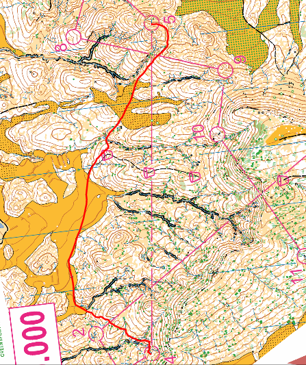
source: https://www.livelox.com/Viewer/Costa-Calida-2024-Larga-Caravaca-/M-35A?classId=716564&tab=player&leg=5

This leg stands out as the only one within this particular group, providing us with limited information for drawing definitive conclusions regarding the winning route. However, we can still make comparisons based on the relative speeds of the athletes, which will offer valuable insights
What do we have?
The leg length is 1660 meters. The climb along the line of the crossing is 135 meters.
The length of the right-hand route is 2400 meters, with a climb of 85 meters (and all these 85 meters are in the first half of the route: 40 meters steep from KP 4, then more gentle).
In fact, only Aleksei Alekseyonok ran the right route (from those who loaded their GPS tracks), securing a significant victory in this leg. (He is also the winner of the course.)

However, this does not imply that the left-hand route along the fields is a losing one.
We will now analyze the routes of the other participants who secured 2nd to 5th place in this leg. (see figure with leg 4-5 times)

2. Raul Ferra attempted to execute this leg close to the leg line, with a climb of approximately 100 meters and a length of 2060 meters.
In comparison to Aleksey, he lost 54 seconds. One might wonder why he lost despite the insignificant difference in altitude gain and a shorter distance of 350 meters. Perhaps it's because Raul had to cross four gullies along the way.

3. Raul Martinez did not choose the optimal route through the field, resulting in an additional 25 meters of elevation gain.Based on comparative paces, I estimate that Raul's loss here was approximately 30 seconds.
How can you determine if your approach to a large feature is optimal? Refer to the useful tip provided at the end of the article.

4. Cesar Torrejon opted for a route on the left side of the field, aiming for the nearest corner. However, he made a mistake while approaching the control. Without this mistake, he could have outpaced Aleksei in terms of relative difference, considering their respective paces. As a benchmark, I compared it to the leg from control 13 to 14, where Aleksei's running pace was 5.30 minutes per kilometer, whereas Cesar's was 7.00 minutes per kilometer.
5. Arturo Garcia Dengra also chose to run on the left side. However, he also did not optimal control approach. Taking into account this pace - he lost 1 minute and 30 seconds to Aleksei per kilometer, while the average pace loss on the course (excluding errors) is approximately 2 minutes per kilometer

From these route and time analyses, I conclude that the left route aiming hit the nearest corner of the field, , would theoretically be advantageous. However, it necessitated a precise move steeply to the left immediately from Control 4. Consequently, this route had to be thoroughly and precisely planned before leaving control 4.
6. Also of interest is the route taken by Alex Tello (10th place on this leg and 6th overall), where he attempted to minimize elevation gain. While he succeeded in this aspect, his speed was not particularly high.

His average times for the legs were the 5th best. Given this, we can estimate that his time for this leg could have been 16 minutes and 30 seconds. However, in reality, it was 21 minutes and 30 seconds, indicating a time loss of about 5 minutes compared to his potential. This is quite significant! It's evident that there was a significant error in route estimation
The conclusions I drew for myself from analyzing this run are as follows:
1. The simplicity of the route influences the pace. It's not only the length and elevation gain that should be considered, but also the amount of orienteering involved.
2. The initial stage of the route is critical in determining the overall favorability of the route.
3. Even a straight route will have some degree of lengthening. Moreover, if it forms a "figure eight" shape, the lengthening effect is similar to that of a large arc.
At the end, as promised, here's some useful advice on 'HOW to assess whether you are making an optimal exit from the control to a significant feature':
Tip: Mentally place the control at the point of your intended exit and envision how you would execute such a leg.
For example, let's consider Raul Martinez's exit to the field. By applying this advice, you can easily recognize that a more optimal route for the 4-A run would be towards the left corner of the field, minimizing altitude gain (mostly horizontal and downwards; BLUE track).

Aleksandr Alekseyonok, 19 March, 2024.
Comments
Post a Comment