
Left, Right, or Straight: Leg Analysis #9

 Left, Right, or Straight: Leg Analysis #9


Today, we will focus on a detailed analysis of leg 14-15 from the women's long course at 'Spring Spartacus' event in Hungary.


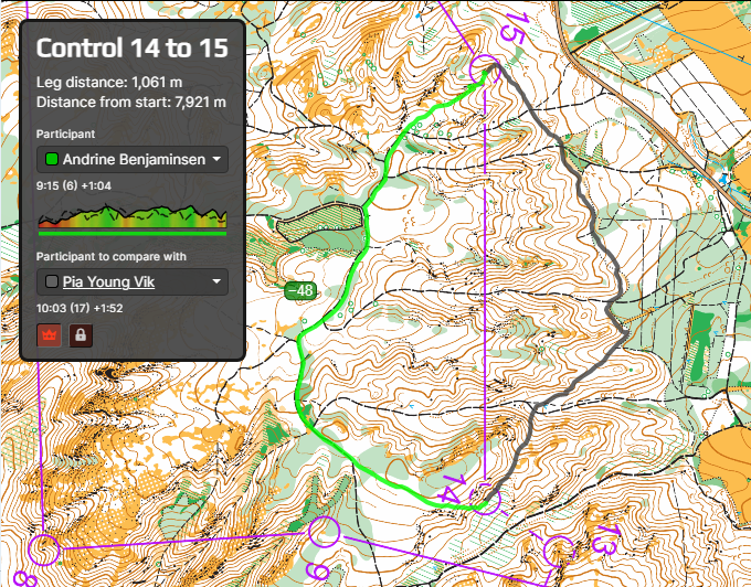
I find the route choice for leg 14-15  to be simple and unambiguous. 
This perception is supported by the GPS tracks of the competitors. Interestingly, only one competitor from this class took the right-hand route out of all those who loaded their tracks on Livelox.


We cannot definitively attribute this deviation to the athlete's error. For many runners, these competitions were part of the training camp for the European Championships 2024. The athlete may have had different objectives than simply completing the course quickly. It's possible that on this leg, she was practicing a challenging technical skill, such as running along a slope.


However, based on this iformation, we can assess how effective the right-hand route was. 
The leg is 1060 metres long, crossing massive landforms. Therefore, one of the first assessments is the positioning of the controls in terms of height.

We can observe that Control 15 is approximately at the same elevation as Control 14, positioned near the middle of the slope. Strategically, we have two options: either ascend directly from Control 14 and then descend to Control 15 (left route), or descend from Control 14 and then ascend (right route). The elevation gain for both routes will be roughly equivalent. However, the left route follows the road, while the right route traverses horizontally along the slope, resulting in a significantly slower pace
The right-hand route is also more difficult to follow.


Compared to the leader of this leg and overall cource Simona Aebersold,  Pia Young Vik lost  on right route 1.52.
However, the leader was noticeably faster than the others athletes in this class.
We took the averall second place Andrine Benjaminsen. Thus,  Pia Young Vik lost to her 'direct competitors' is 48 seconds. 

comparison with the second time on the leg of Rita Máramarosi (5th place overall): + 1.07

(I will provide further explanation about 'direct competitors' and its relation to navigation in Confident Orienteering Book 2 'Planning and Execution of Routes', which is slated for release, if all goes well, by the end of 2024.

In the meantime, you can purchase and study Confident Orienteering Book 1, which is about the principles on which my author's 'Сonfident Оrienteering' navigation approach is based)

We can also see that Pia's approach to Control 15 was not optimal. It could have resulted in a loss of 15-20 seconds less. So my prediction that the right route would lose at least 1 minute was not entirely accurate.

In M20 Class this leg was 12-13. And also most of runners took left-hand route. 


Source: https://www.livelox.com


Aleksandr Alekseyonok, April 11, 2024


Comments

Popular posts from this blog

  Case Study #4 Case: You ran onto a narrow ride slightly below its end and are unsure which of several similar rides you are on.   Solution: In this situation, the relief profile can assist us. Even if the rides themselves appear similar, the relief profile along each ride differs , providing valuable clues for accurate positioning. This approach is discussed in Chapter 3 ( Using All the Indicators for Confident Positioning ) of the book Planning Reliable Routes . It demonstrates that relief can be used not only when we are uncertain about our current location , but also proactively during route planning . By analysing the map in advance, we can identify segments where linear features intersect with relief forms , creating distinct and easily recognisable points. These can serve as reliable positioning features . Additionally, flat areas and transitions between slopes and level terrain can also support effective location verification. (Example taken from my book Plann...

New o-book is coming this fall!

  New O-Book Coming This Fall! Confident Orienteering: A Systematic Approach to Minimising Errors Book 1: Fundamentals was released in October 2023 and has already been translated into seven languages , alongside the original English edition. With 8 chapters and 140 pages, it introduced the core concepts of the author's navigation system — and I’m still amazed at how warmly it was received by orienteers around the world. 🌍 As we continued working on the next part of this practical guide, it became clear that the project had grown into something much bigger — not least because of the sheer number of examples and illustrations included throughout (around 250 in total!). To make the material easier to absorb, we’re now leaning towards splitting it into two volumes , each with its own clear focus. This isn’t a final decision yet, and even the titles below are working titles — but right now, this structure feels like the most reader-friendly option: 📖 Book 2 (working title...

The Road to JWOC 2026, #2 (Long Distance)

  The Road to JWOC 2026, #2 (Long Distance) Short  Leg 1: what to do In the previous post in this series, we identified—based on the terrain characteristics and extensive experience from many previous competitions in this area—that a short first leg with complex navigation is highly likely. In this post, we focus on what exactly to do in such a situation. Let us begin by explaining why we are specifically discussing short first legs . If the first leg is longer , it will most likely intersect paths , as this terrain is full of paths of different types . In that case, an athlete has several safety options : – choosing a detour along paths; – or navigating less precisely on a bearing , deliberately aiming off early to hit a path and then restoring exact position while running along it. https://www.livelox.com/Viewer/JVM-test-lang/D20?classId=392774&live=false&tab=player In such scenarios, the initial nervousness and uncertainty at the beginning of the co...