
Left, Right, or Straight: Leg Analysis #16


 Left, Right, or Straight: Leg Analysis #16


We often have to choose from several possible routes on a leg, typically from two.

Sitting at the table, we can use a ruler to determine the route accurately, but we are interested in quick calculations that can be performed under race conditions.


An approximate order of operations for this leg might be as follows:

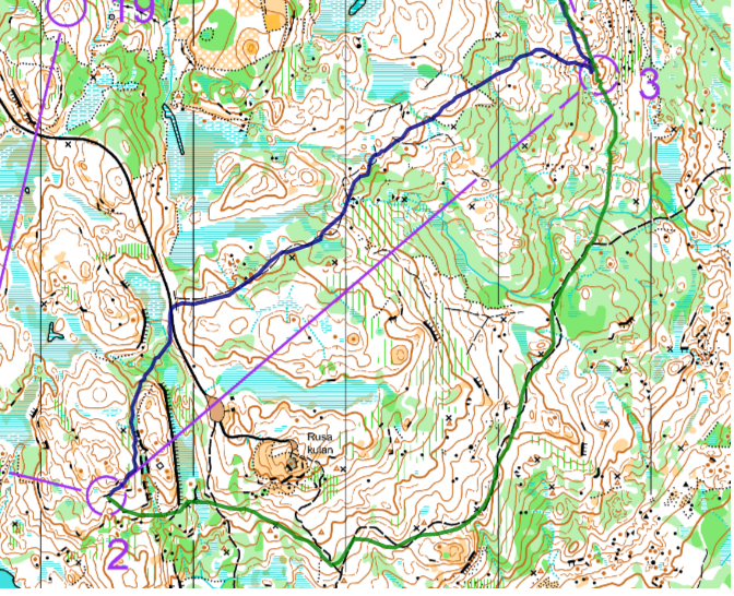
  1. We make an assessment of the main idea of this leg and a general assessment of the relief. We have a difficult control point (control 3) on a slope. Two possible route choices are immediately obvious, as we need to avoid the big cliff at the start of the leg.

    Right route: using the main road with a long approach to the control.

    Left route: taking the trail, which has less extension. The approach to the control is also long but seems easier as it goes from above downwards.

    Relief assessment: we are descending 50 metres on this leg. The left route has no elevation gain, while the right route leads to a road that goes below the level of control 3. Approaching the control, we will have to climb 10–15 meters. It's not much, but still noticeable.


2: A choice of two route ideas:

We can safely add 30% to the length of the ringt approach, and it will be an equally time-efficient left approach (sections 1L and 1R).

The exits from control 2 are also roughly similar in length and difficulty (sections 2L and 2R).


It remains to be decided which is faster and better for us to execute: Section 3L or Section 3R.


In practice, the results of the leaders on both routes (from those who have uploaded their GPS tracks)


Agnes Nørgård Kracht
Västerviks OK - best time on this leg.
Frida Vikström
Sundsvalls OK - 8 time on this leg. 

Below you can see the paths of the top 10 runners. only 2 of them ran right (8th and 10th place).


Source: Livelox

Aleksandr Alekseyonok, June 17, 2024. 


Comments

Popular posts from this blog

  Case Study #4 Case: You ran onto a narrow ride slightly below its end and are unsure which of several similar rides you are on.   Solution: In this situation, the relief profile can assist us. Even if the rides themselves appear similar, the relief profile along each ride differs , providing valuable clues for accurate positioning. This approach is discussed in Chapter 3 ( Using All the Indicators for Confident Positioning ) of the book Planning Reliable Routes . It demonstrates that relief can be used not only when we are uncertain about our current location , but also proactively during route planning . By analysing the map in advance, we can identify segments where linear features intersect with relief forms , creating distinct and easily recognisable points. These can serve as reliable positioning features . Additionally, flat areas and transitions between slopes and level terrain can also support effective location verification. (Example taken from my book Plann...

New o-book is coming this fall!

  New O-Book Coming This Fall! Confident Orienteering: A Systematic Approach to Minimising Errors Book 1: Fundamentals was released in October 2023 and has already been translated into seven languages , alongside the original English edition. With 8 chapters and 140 pages, it introduced the core concepts of the author's navigation system — and I’m still amazed at how warmly it was received by orienteers around the world. 🌍 As we continued working on the next part of this practical guide, it became clear that the project had grown into something much bigger — not least because of the sheer number of examples and illustrations included throughout (around 250 in total!). To make the material easier to absorb, we’re now leaning towards splitting it into two volumes , each with its own clear focus. This isn’t a final decision yet, and even the titles below are working titles — but right now, this structure feels like the most reader-friendly option: 📖 Book 2 (working title...

The Road to JWOC 2026, #2 (Long Distance)

  The Road to JWOC 2026, #2 (Long Distance) Short  Leg 1: what to do In the previous post in this series, we identified—based on the terrain characteristics and extensive experience from many previous competitions in this area—that a short first leg with complex navigation is highly likely. In this post, we focus on what exactly to do in such a situation. Let us begin by explaining why we are specifically discussing short first legs . If the first leg is longer , it will most likely intersect paths , as this terrain is full of paths of different types . In that case, an athlete has several safety options : – choosing a detour along paths; – or navigating less precisely on a bearing , deliberately aiming off early to hit a path and then restoring exact position while running along it. https://www.livelox.com/Viewer/JVM-test-lang/D20?classId=392774&live=false&tab=player In such scenarios, the initial nervousness and uncertainty at the beginning of the co...