
Analysis of the terrain for the upcoming competition #1

Analysis of the terrain for the upcoming competition #1


I found an advertisement online today for an upcoming event "Alaska Orienteering Festival" in Alaska. The event  will take place on the 3rd and 4th of August, 2024. Event's Website

The first day will feature a very challenging map called Willow Creek, as presented on the competition website.


Here are several key observations about this terrain that I can highlight based on the map analysis:

Judging by the photo next to the map on the competition website, visibility in the forest is quite limited for open forest.


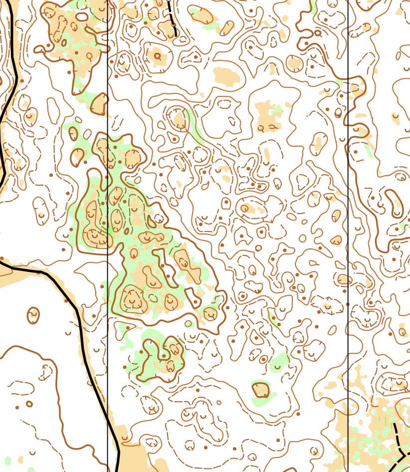
 The terrain is very gentle, with a relief (it is looks like contour interval 2.5 on this map). However, the main difficulty lies in the fact that the terrain does not provide clear, long navigational lines that can be followed on the leg to more easily keep to the planned direction of travel.

In the example below, you can see how short and oriented in different directions the navigational lines of the spurs and ridges are.

If you're not familiar with the term "navigational lines" and how they help build reliable navigation, read the book "Confident Orienteering Book 1: Fundamentals."


There are also a lot of similar landforms, such as hilltops and depressions. In addition, it can be seen that the relief structure is very complex. It consists of one gentle stepped slope with depressions at different levels. 

In the figure, the red lines indicate the index lines (levels 1 and 2), while the blue lines represent the contour lines between them. Depressions at different levels are shown in various colours.


Thus, I predict that the participants will make a lot of mistakes despite the very good runnability of this forest. There will likely be many significant errors, such as "total loss" in the control area and in the middle of the route in long legs. The lack of small paths and clear vegetation boundary lines also contributes to this.

However, there is one feature that will be very helpful in navigation: depressions with clearings. I would rely on these pits in the first place and try to use them on the route


And in general, I would build the route as a chain of short, bearing sections between distinct hilltops and depressions. And of course, it is important to have good distance monitoring. Those who can measure the distance in steps will have an additional advantage on this map. 


A book for experienced orienteers on how to reduce errors on courses is available here.

Also this book is already available in French, Ukrainian and Danish (please contact me if you need a link to any of these books).

Aleksandr Alekseyonok, July 11, 2024.

Comments

Popular posts from this blog

  Case Study #4 Case: You ran onto a narrow ride slightly below its end and are unsure which of several similar rides you are on.   Solution: In this situation, the relief profile can assist us. Even if the rides themselves appear similar, the relief profile along each ride differs , providing valuable clues for accurate positioning. This approach is discussed in Chapter 3 ( Using All the Indicators for Confident Positioning ) of the book Planning Reliable Routes . It demonstrates that relief can be used not only when we are uncertain about our current location , but also proactively during route planning . By analysing the map in advance, we can identify segments where linear features intersect with relief forms , creating distinct and easily recognisable points. These can serve as reliable positioning features . Additionally, flat areas and transitions between slopes and level terrain can also support effective location verification. (Example taken from my book Plann...

Left, Right, or Straight: Leg Analysis #21

  Left, Right, or Straight: Leg Analysis #21 Today we will take a look at Leg 5–6 from the M18 Long Distance course at the   Novembertävlingarna, lång event (23.11.2025) Organising club Tullinge SK (Sweden) In the M18 class, the most successful route choices used a less distinct path running between the hills. In general, the approach to the control could be planned either contouring around the hillside or crossing over the top . This decision largely influenced the entire route choice on this leg. Interestingly, both of these approaches were used by the fastest runners on this leg (Carl-Meijer Axelsson and Jonathan Enarsson) — and both produced very similar results . The athlete who placed 3rd on this leg - Ivar Nordberg (and eventually 3rd overall ) most likely made a mistake. After reaching the top of the hill , he deviated down toward the open field — a move that doesn't seem justified. Most likely, he lost direction while descending the slope. This leg also ...

New o-book is coming this fall!

  New O-Book Coming This Fall! Confident Orienteering: A Systematic Approach to Minimising Errors Book 1: Fundamentals was released in October 2023 and has already been translated into seven languages , alongside the original English edition. With 8 chapters and 140 pages, it introduced the core concepts of the author's navigation system — and I’m still amazed at how warmly it was received by orienteers around the world. 🌍 As we continued working on the next part of this practical guide, it became clear that the project had grown into something much bigger — not least because of the sheer number of examples and illustrations included throughout (around 250 in total!). To make the material easier to absorb, we’re now leaning towards splitting it into two volumes , each with its own clear focus. This isn’t a final decision yet, and even the titles below are working titles — but right now, this structure feels like the most reader-friendly option: 📖 Book 2 (working title...